


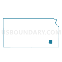
Prairie Township Voting District, Wilson County, Kansas
About
Outline

Summary
| Unique Area Identifier | 587616 |
| Name | Prairie Township Voting District |
| County | Wilson County |
| State | Kansas |
| Area (square miles) | 30.13 |
| Land Area (square miles) | 29.97 |
| Water Area (square miles) | 0.16 |
| % of Land Area | 99.47 |
| % of Water Area | 0.53 |
| Latitude of the Internal Point | 37.60530160 |
| Longtitude of the Internal Point | -95.82252720 |
Maps


Graphs
Select a template below for downloading or customizing gragh for Prairie Township Voting District, Wilson County, Kansas


Neighbors
Neighoring Voting District (by Name) Neighboring Voting District on the Map
- Center Township Voting District, Wilson County, KS
- Clifton Township Voting District, Wilson County, KS
- Fall River Township Voting District, Wilson County, KS
- Guilford Township Voting District, Wilson County, KS
- Verdigris Township Voting District, Wilson County, KS
- Webster Township Voting District, Wilson County, KS
Top 10 Neighboring County Subdivision (by Population) Neighboring County Subdivision on the Map
- Center township, Wilson County, KS (505)
- Clifton township, Wilson County, KS (364)
- Fall River township, Wilson County, KS (359)
- Verdigris township, Wilson County, KS (322)
- Guilford township, Wilson County, KS (168)
- Prairie township, Wilson County, KS (130)
- Webster township, Wilson County, KS (48)